Google Earth for the Classroom

| google_earth_voice_tour.wav |
| File Size: | 5292 kb |
| File Type: | wav |
Download File
Learn about some of the new Google Earth features in the following short video:
Google Earth Offers a WEALTH of Amazing Learning Opportunities for Students!
What you can do with Google Earth is limited only by your imagination! There are applications that allow you to see landforms from a first-person perspective, view historical images and changes over time, fly into space to see stellar objects in their actual positions in the sky, create tours for students, and much more. There is a great deal more potential for learning here than I can even comprehend. For a sample of the possibilities view this slideshow of ways to use google tools to enrich Social Studies lessons (also linked to pic on the left). Not just for students, my entire family has been in awe of where we can go with this amazing tool.
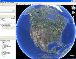
My Experience Making a Tour:
Within a half an hour I was able to create a tour of North America, looking specifically at land formations and important waterways. This 2nd grade content has been taught for years with students drawing 2D pictures on paper, but never really understanding how it would translate to our real environment. With Google Earth they could actually BE at these places, SEE the topgraphy in 3D view, FLY to places, having an idea of actual scale and breadth that could never have been grasped before. I can now use this tour repeatedly, as an independent activity or whole class and update it as I learn more about all the tools Google Earth has embedded.
Some Ideas For Using Google Earth in the Classroom:
In 2nd grade science we study Volcanoes as part of learning about geology (view link below). We could visit 3D views of volcanoes to develop the understanding of how they cause new land to form and how they are caused by their positions on techtonic plates. In fact, we could create an inquiry-based webquest, viewable on the G.E. page, that allows students to develop their own understanding of the formation and consequence of volcanoes while working in groups.
When learning about the Solar System in 3rd grade student can visit each planet, understand its location in relation to the Earth and comprehend the immense distances between the planets.
In studying Ancient Rome, students can go back to visit a 3D 1st person ground perspective of landmarks from that era, as they looked then. Places to view include the Colluseum, Senate, etc.
For understanding the implications of Geo-Socio Economics, students could look at the image overlays of prosperity vs. poverty and determine possible relationships between where people live and how they live.
For the 1st grade Oceans curriculum, teacher can set up a tour of the oceans that can be played for students without their needing to press and keys. There are also videos embedded of ocean animals in their real environments. These little ones will have the opportunity to view real pictures of real oceans in exact proportions and spatial placement.
Connect the students to current or historical events, by having them visit places in the news, trace back through empires being built, wars being fought (How does terain affect tactics?).
There could be no better way to learn and understand how maps work, differing map perspectives, longitude and latitude/ time, distance, and Geo-mechanics.
The possibilities are endless!
_________________________
Example Tours:
Below are listed two links to tours created by educators like us:
You must have the new version of Google Earth downloaded on your computer before they will run.
_____________________________
Google Earth Tutorials: